The viking mappping project
September 2nd to 5th 2010 ISE is launching an archeological survey project off the coast of Denmark.
Aim of the project is to map and survey three wrecks off the coast of Nykobing whose history remain a mystery althought the existance of the ships is known to local divers since the 60s. The project is lead by Danish ISE Instructor Morten Dall Damer togeher with ISE president Achim Schloeffel
Project Diary:
September 2nd 2010
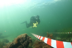
Although the Wrecksite is generally known to local divers task no1 today was to relocate the wrecks and intall morrings and a permanent line to make access to the wrecks easier for the coming dives.
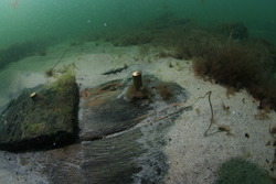
The first attempt was made in the morning by Achim Schlöffel and Morten Dall Darmer using scooters to check the site. After approx. one hour pieces of wreckage were located and marked west of where the wrecks should be. The parts were cleary from our wrecks but seemed to be scattered over a wider area.
After a short break a second attempt was made by Dirk Zielinski and Florian Pirschle on the scooters, checking the area east of the first site. A second team of Rene Hansen and Michael Hansen went in the water to exchange the markings that were set by the morning team by permanent moorings.
Achim Schlöffel and Morten Dall Darmer took the boat and went on to search with the Sidescanner. In the late afternoon those effords were rewarded and two wrecksites were found south east of the wreckfield from the first dive.
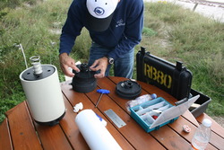
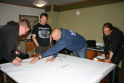
The evening was spent transfering date from wetnotes to a big map that is based on the land survey Michael Vill did on the beach during the morning
September 3rd 2010
The second exiting day of the project is over and a lot of work was done.
In the morning the first team of Michael Vill and Rene Hansen scootered out to the wrecksite and started to measure and map the remains of the what we call Viking 1 - which is the biggest of the wrecks.
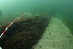
Team 2 (Morten Dall Darmer and Michael Hansen) and 3 (Rene Kofoed and Florian Pirschle) scootered out 30 min later and started to install the grid in 2 x 2 meters. The dives had runtimees up to 140 min. Achim Schlöffel spend the dive documenting the wrecks and the effords of the teams with the camera.
After a brief lunchbreak Rene Hansen and Rene Kofoed went in again to finsh the work of installing the grid while Achim Schloffel and Dirk Zielinski sketched and measuerd the broken parts of Wreck 3.
The evening was spent putting more details in the overview map and finally get a picture of what the wreck looks like on the bottom.
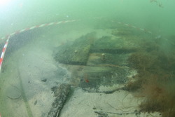
The main wreck (Viking1) has an overall length of approx. 30 meters with a 7 meater beam which means that it was at least around 40 meters long and 8meters wide when it was still afloat.
September 4th 2010
The last day of diving. The "mapping" team of Michael Vill and Rene Hansen went out to measure what we christianed "Viking 2" and is a second wreck sitting slightly angled almost on top of Viking 1. Rene Kofoed and Florian Pirschle did some last adjustments to the grid before Achim Schlöffel went out doing the grid photography.
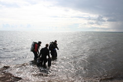
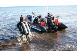
Morten Dall Darmer was responsible for the Boat today supporting the divers with shuttle service to and from the wrecksite as well as delivering scooters, and additional gear.The weather got worse as the morning passed by. We skipped the lunchbreak and continued with the work.
Achim and Dirk did some detail pics from spots of the wreck that showed details of construction work, planking and plank covers.Late afternoon, Luise Riber, Michael Hansen, Dirk Zielinski and Rene Hansen finished the day´s work and removed the grid and all lines so the wrecksite was left as we found it.
The evening was spent printing out the grid pics and arranging a preview pic of what will be done the coming weeks on the computer - a photomosaique of the wreck. The maps were filled with the additional information.
Conclusion:
After 3 days of diving we gathered enough information to talk to historians, shipengeneers and archeologists to find out what we found, and what can or should be done in a further Expedition.
The combination of exact mapping, photodocumentation, and collection of details will enable the professional archeologist to date a jear and shiptype to the Wrecks and shine some light on this piece of history.
Today we know that there are two wrecks of at least 35 and 26 meters long, that most probably sunk together, maybe due to a storm or a collision. The date might be between 1600 and 1650 - which is a rough guess after studiing some documents.
We will keep you posted on how this story continues.. please check back frequently.
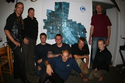
Participants:
Morten Dall Darmer
Michael Hansen
Rene Hansen
Rene Kofoed
Florian Pirschle
Luise Riber
Achim Schlöffel
Michael Vill
Dirk Zielinsky
We would like to than the following companies and individuals for their help and support:
Bonex Exploration Systems - Christiane Bonetsmüller
Light Monkey - Corey Mearns
Autohaus Schlöffel - Andreas Schlöffel
Deutsches Museum München
THE-INNER-SPACE.COM
Dive Data
Fromandsklubben Baltic
Some pictures